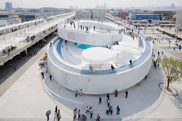
EXPO 2010 Denmark Pavilion


 (2 vote, 70.00% worth checking out)
 Location:
EXPO 2010 Shanghai
Zone C of the Expo Site
Shanghai
China
coordinates: 31.1848545,121.4774780
open coordinates in google maps
open coordinates in apple map
Building names(s): EXPO 2010 Denmark Pavilion
Architect/Designer: BIG with ARUP and 2+1
architect website:
more images:
Completion date: 2010
function(s): expo, pavilion
Theme: The Sensual City Highlights: A Style of Floating Theme: Welfairytales Highlights: Double Spiral The pavilion is a double spiral with pedestrian and cycling lanes that takes the visitors from the ground through two ramps, up to a level of 12 meters, and down again. The pavilion paints its steel structure white, to represent the sailing traditions of the country and to help keep the pavilion cool. In the pavilion visitors will be able to borrow bicycles and cycle throughout just as the Danes do in their cities. The concept of sustainability is reflected in free bicycle riding. Riding a bike through an area which is designed like Copenhagen streets will not only evoke the real Danish lifestyle in the capital city, but also promote environmentally friendly concepts. Denmark is a nation of bikes, and Copenhagen is famous for its free city bikes. website: www.expo2010.dk getting to the expo site: For visitors’ convenience to the Expo Site, Shanghai is constructing a comprehensive urban transport system and an Expo public transport network which enables visitors to reach the Expo Site via rail transit, bus and water transportation. There is one metro line entrance/exit, eight ground entrances/exits, four extra-Site and three intra-Site water gates.Metro Line Entrance/exit : Puxi Section - Madang Road Station of Metro Line 13
Ground Entrance/exit :
Puxi Section - Entrance/exit at Luban Road, South Xizang Road, Bansongyuan Road
Pudong Section - Entrance/exit at Bailianjing, West Gaoke Road, Shangnan Road, Changqing Road, Houtan
Water Entrance/exit:
Extra-Site Water Gate - Dongchang Road Water Gate, Qichangzhan Water Gate, Shiliupu Water Gate, Qinhuangdao Road Water Gate
Intra-Site Water Gate
Dock 1 (Miaojiang Road • Wangda Road)
Dock 2 (Expo Avenue • Bailianjing Road)
Dock 6 (Houtan Garden)
Intra-Site Transport On most occasions, visitors can get to pavilions on foot in the Expo Site. Since the Expo Site is divided by the Huangpu River and there is quite a distance between the zones, the Organizer sets up a public transport system including metro line, bus and cross-river ferry. Metro LineMetro Line 13 is designed to facilitate visitors’ travelling between Pudong and Puxi Sections. There are Madang Road Station, Lupu Bridge Station, and Expo Avenue Station on the line.
Ground TransportFive bus routes, including two sightseeing routes, are designed to facilitate visitors’ touring in Pudong or Puxi
Section and traveling between the two sections.
Water TransportFive ferry routes are designed to facilitate visitors’ traveling between Pudong and Puxi Sections.
