The Moses Bridge

 (3 vote, 80.00% worth checking out)
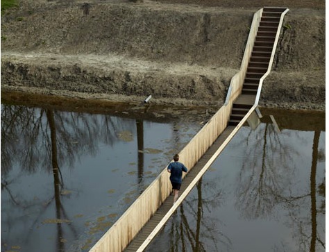
RO&AD
Location:
Fort De Roovere
Schansbaan & Ligneweg streets
Halsteren
Netherlands
coordinates: 51.5289192,4.3009758
open coordinates in google maps
open coordinates in apple map
Building names(s): The Moses Bridge
Architect/Designer: RO&AD Architecten
architect website: www.ro-ad.org
more images:

RO&AD
Completion date: 2011
completion date: 2011
function(s): bridge
check out: This bridge is found along the access route to the historic 17th Century site of Fort de Roovere. However, unlike a conventional bridge, the structure is sunken down into the moat, thus rendering it invisible from a distance, minimising it's impact on surrounding views towards the fort.